Cumulonimbus cloud Facts
By mavic..Otherwise known as The King of Clouds, cumulonimbus clouds exist through the entire height of the troposphere, usually characterised by their icy, anvil-shaped top.
- Height of base: 1,100 - 6,500 ft
- Shape: fibrous upper edges, anvil top
- Latin: cumulus - heap; nimbus - rain cloud
- Precipitation: heavy rain and thunderstorms
What are cumulonimbus clouds?
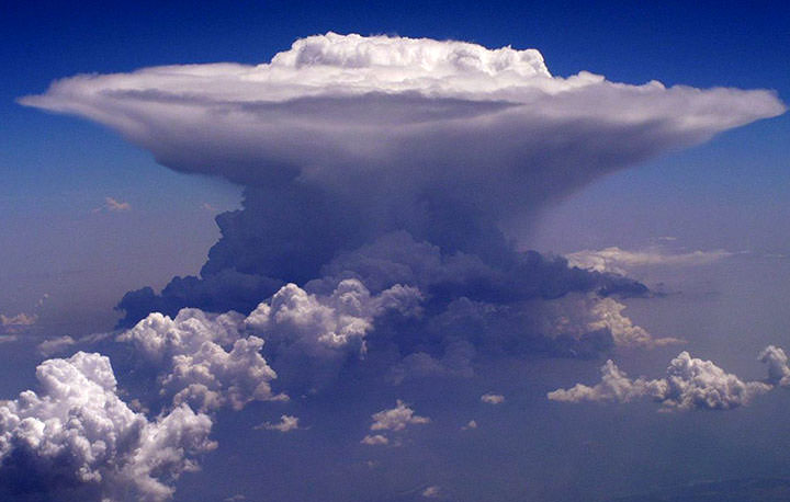
Cumulonimbus clouds are menacing looking multi-level clouds, extending high into the sky in towers or plumes. More commonly known as thunderclouds, cumulonimbus is the only cloud type that can produce hail, thunder and lightning. The base of the cloud is often flat, with a very dark wall-like feature hanging underneath, and may only lie a few hundred feet above the Earth's surface.
How do cumulonimbus clouds form?
Cumulonimbus clouds are born through convection, often growing from small cumulus clouds over a hot surface. They get taller and taller until they represent huge powerhouses, storing the same amount of energy as 10 Hiroshima-sized atom bombs. They can also form along cold fronts as a result of forced convection, where milder air is forced to rise over the incoming cold air.
What weather is associated with cumulonimbus clouds?
Cumulonimbus clouds are associated with extreme weather such as heavy torrential downpours, hail storms, lightning and even tornadoes. Individual cumulonimbus cells will usually dissipate within an hour once showers start falling, making for short-lived, heavy rain. However, multicell or supercell storms contain many cumulonimbus clouds and the intense rainfall may last much longer.
If there is thunder, lightning or hail, the cloud is a cumulonimbus, rather than nimbostratus.
How do we categorise cumulonimbus clouds?
Cumulonimbus clouds have 3 distinct 'species' which describe the appearance of the head of the cloud:
- Cumulonimbus calvus - the top of the cumulonimbus is puffy, like a cumulus cloud. The water droplets at the top of the cloud tower have not frozen to become ice crystals.
- Cumulonimbus capillatus - the top of the cloud is fibrous but relatively contained. Water droplets have started to freeze, usually indicating rain has begun or will begin soon.
- Cumulonimbus incus - the top of the cloud is fibrous and anvil-shaped, as the cloud has continued to grow. If the cloud reaches the top of the troposphere and still wishes to grow, it must do so outwards, creating the picturesque anvil or 'incus'.